







Verified on
Philippines ferry routes map
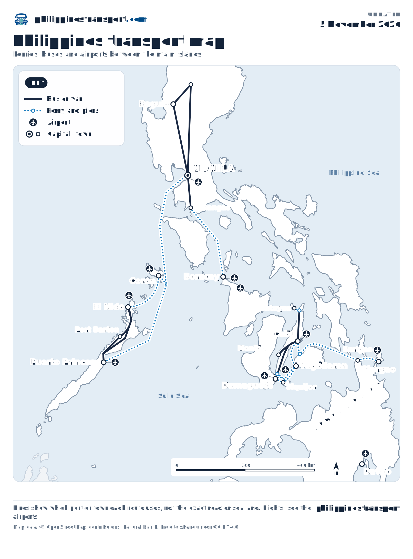
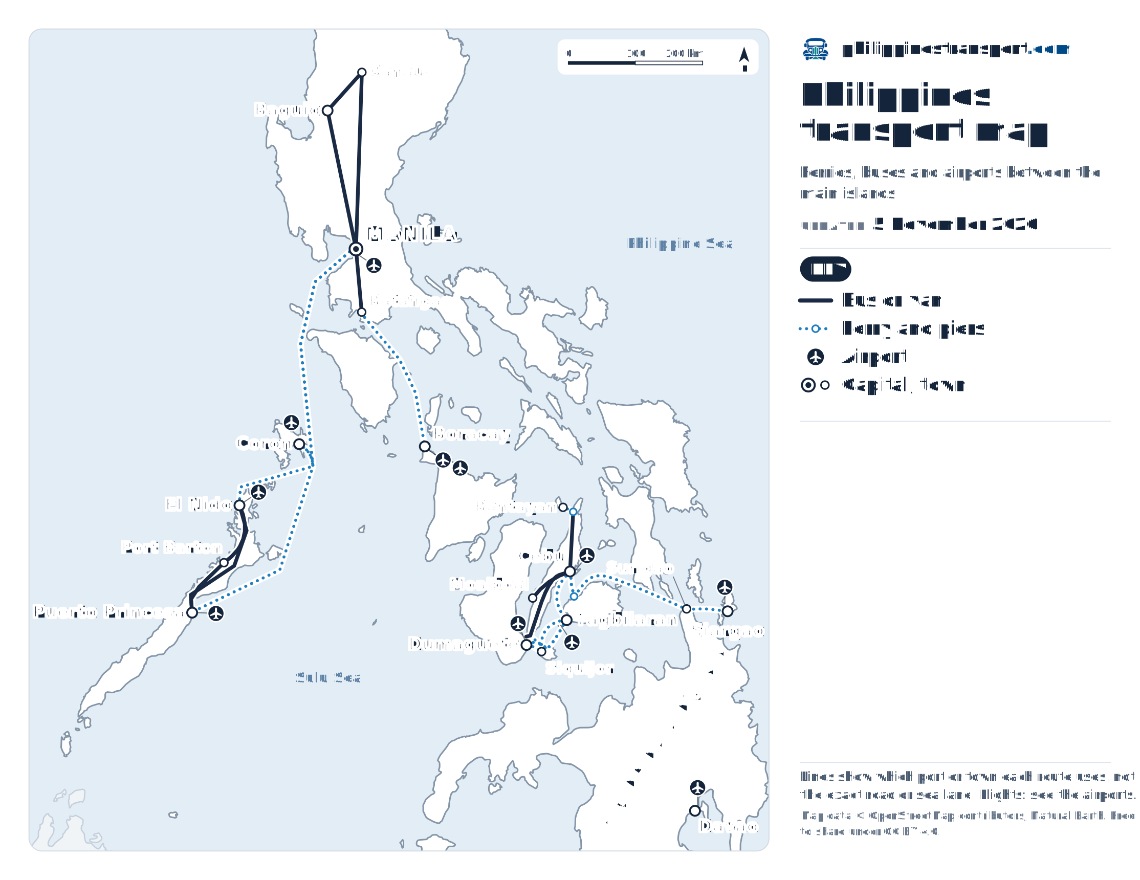
Dotted blue lines are the ferries most island trips use: Batangas to Boracay, Cebu to Tagbilaran and Tubigon on Bohol, Bohol on to Siquijor and Dumaguete, Surigao to Siargao, El Nido to Coron, and 2GO's ships from Manila to Puerto Princesa and Coron. Solid dark lines are buses and vans; plane symbols are airports with flights between the islands. One tap opens it full screen, with zoom.
Island-hopping chains you can trace on the map
Manila to Boracay without flying
A bus from Manila to Batangas, then an overnight boat from Batangas Port to Caticlan, then 10 to 15 minutes by boat to Boracay.
Cebu, Bohol, Siquijor and Dumaguete as a loop
Fast craft leave the Cebu City port for Tagbilaran, and roll-on roll-off ferries for Tubigon. From Tagbilaran, boats carry on to Siquijor, Larena and Dumaguete, and the Dumaguete–Siquijor crossing takes about an hour, so the four islands close into a circle without doubling back through Cebu. Overland, Cebu's southbound buses reach Oslob, for the boat to Larena, and Liloan, for the short hop to Sibulan beside Dumaguete.
Cebu to Siargao
Boats from the Cebu City port to Surigao, then a fastcraft across to Dapa on Siargao.
Palawan: Puerto Princesa, Port Barton, El Nido, Coron
Buses and vans run up the island from Puerto Princesa to Port Barton and El Nido; from El Nido the fast ferry crosses to Coron. 2GO's ships from Manila North Harbor reach both Puerto Princesa and Coron. The Palawan guide has the days each boat sails.
The rest of Cebu and northern Luzon
Moalboal, on Cebu's west coast, is a bus ride from the city, and a bus to Hagnaya meets the ferry to Bantayan. In the north, buses link Manila, Baguio and Banaue, the road to the rice terraces.
Airports with flights between the islands
Each plane symbol is an airport with flights between the islands: Manila (NAIA), Mactan-Cebu, Panglao on Bohol, Puerto Princesa, El Nido, Busuanga for Coron, Caticlan and Kalibo for Boracay, Dumaguete, Sayak on Siargao and Davao. Flight lines are left off so the boats stay readable; the flights guide has the airlines on each route.
Embed it on a dive shop, hostel or blog page
Any website may show the map at no cost under Creative Commons Attribution 4.0, as long as PhilippinesTransport.com is credited with a link here. This code carries the credit for you:
It loads the current map in the visitor's layout, tall on a phone and wide on a laptop, and opens a zoomable full-screen view on a tap. A page that blocks scripts shows the map as a plain linked image.
For a printed handout or an offline copy, the vector files work at poster size: tall version, wide version. The ports, towns and routes they are drawn from are listed on the About page as data files.
Ports from OpenStreetMap, routes from the island guides
Every ferry terminal, town and airport is placed at its OpenStreetMap position, over Natural Earth's coastline. A route is drawn only when one of the island or route guides covers it with its own sources. Lines join the ports a route uses rather than tracing the sea lane, and Boracay's line ends on the island itself, since Caticlan jetty port is 10 to 15 minutes away by boat.
Island-hopping questions the map answers
Is there a ferry from Manila to Boracay?
Not from Manila itself. The overnight ferries leave from Batangas Port, two hours south of Manila by bus, and land at Caticlan jetty port, across the strait from Boracay. The Manila to Boracay guide has the sailings.
Can I go from Cebu to Siargao by ferry?
Yes, in two legs: a ferry from the Cebu City port to Surigao, then a fastcraft from Surigao to Dapa on Siargao. The Siargao guide has both legs and the timings that connect.
Can a resort or dive shop put the map on its website?
Yes, at no cost, under CC BY 4.0, as long as PhilippinesTransport.com is credited with a link to this page. The embed code in the section above includes that credit.
Port authorities